Umpqua Waterfall Corridor: 16 Stops Along Oregon’s Highway of Waterfalls
More than a dozen waterfalls are tucked along and around Highway 138 in Southern Oregon, earning this stretch of the Rogue–Umpqua Scenic Byway the nickname the “Highway of Waterfalls.” With roadside cascades, short family-friendly hikes, swimming holes and a few bigger adventures, it’s an easy route to customize around how much time and energy your group has.
We first drove this scenic byway on a trip to Crater Lake in September 2014 by accident. The scenic drive along Umpqua river was so memorable, we immediately knew we wanted to come back. More than ten years later, we finally did—although not quite as planned.
Wildfire smoke had completely covered Crater Lake, so we changed course and spent the day exploring the Umpqua Waterfall Corridor instead. We traveled with our five-year-old and parents in their seventies, which gave us a good sense of which stops work well for families and multi-generational trips.
The landscape had changed since our first visit. Wildfires had burned large sections of forest, but we could also see new growth beginning around the blackened trees. Even with those changes, the rivers, mountain scenery and waterfalls were still incredibly beautiful.
We explored Highway 138 from west to east, starting near Glide and ending at Diamond Lake. Along the way, we stopped at everything from waterfalls only a few steps from the parking lot to longer hikes like Toketee and Watson Falls.
In this guide, I’ll share practical waterfall stops along the Umpqua Waterfall Corridor, including how much hiking each requires and which ones worked best for our family. Whether you have a few hours on the way to Crater Lake or a full day to waterfall-hop, I’ll help you decide which stops to prioritize—including the hike that ended up being our favorite.
Umpqua Waterfall Corridor: Quick Overview
- Location: Highway 138 between Roseburg and Diamond Lake in Southern Oregon
- Route: Approximately 80 miles from Glide to Diamond Lake
- Best for: Waterfall lovers, families, road trips and travelers visiting Crater Lake
- Highlights: Waterfalls, short hikes, swimming holes, rivers, hot springs and mountain lakes
- Time needed: One full day for the major stops; longer if you want to hike, swim or explore the Lemolo Lake area
- Facilities and Services: Limited or unavailable between Glide and Diamond Lake
Map of Umpqua Waterfall Corridor

Since there were so many stops, the google map directions had to be split into two link –

Things to Do Along the Umpqua Waterfall Corridor
1. Colliding Rivers — Mile 16
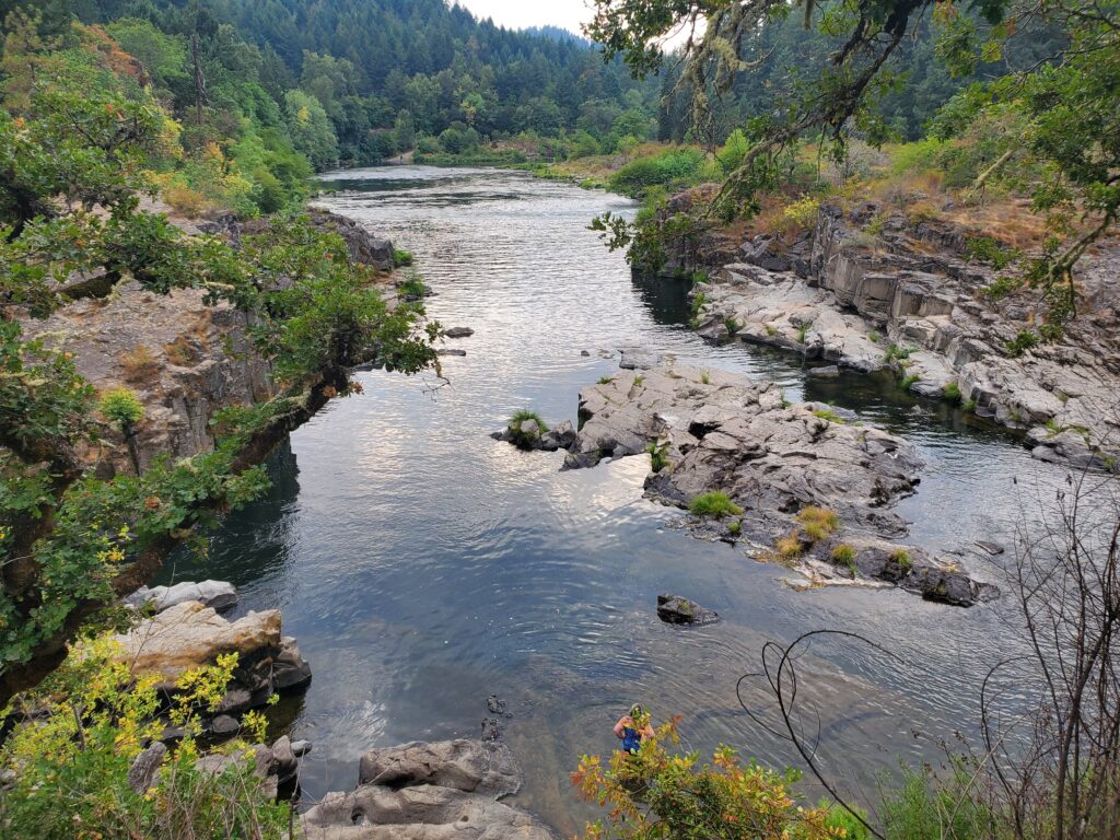
Located near the town of Glide, approximately 16 miles northeast of Roseburg, Colliding Rivers is the first stop on this Highway 138 itinerary.
This is where the Little River meets the North Umpqua River at an almost head-on angle. The unusual meeting point is why the area is called Colliding Rivers.
You can see the collision more clearly during winter or spring, when both rivers are flowing strongly. During summer, the confluence may not look quite as dramatic.
There is a small trail to the left of the viewpoint that leads toward the riverbed. During our visit, the water was low and the area did not appear especially well maintained, so we did not enjoy hanging out here for too long. But it was still a decent place to stretch our legs.
From the main viewpoint, we watched teenagers jumping from the basalt rocks while younger kids waded in the calmer sections of the river.
The viewpoint is directly off Highway 138 and easy to access, with convenient parking. A visitor center and restrooms are located here, although neither was open during our visit.
2. Swiftwater Park and Bridge — Mile 22
Swiftwater Park is a pleasant riverside pullout with picnic tables, restrooms and views of the North Umpqua River. It works well as a quick leg-stretcher, particularly if you are traveling with kids. The area is also popular for fishing.
Walk onto the Swiftwater Bridge for a wider view of the river. You can also see Deadline Falls from a distance.
For a closer look at the falls, cross the bridge and drive to the North Umpqua Trail parking area. The first quarter-mile of the North Umpqua Trail is accessible and leads to a viewpoint overlooking Deadline Falls.
3. Deadline Falls — Mile 22
(0.5 miles to 0.1 mile)

Deadline Falls looks less like a traditional waterfall and more like a wide, powerful cascade across the North Umpqua River.
There are two ways to see it more closely:
- North Umpqua Trail: 0.5 mile round trip. Cross Swiftwater Bridge and drive to the North Umpqua Trail parking area. Follow the first quarter-mile of the trail to the official viewpoint.
- Roadside path: Less than 0.1 mile round trip. Stop at the turnout closest to the falls and walk approximately 100 feet along an unofficial, somewhat overgrown path. This is the route we used.
Deadline Falls may not be the most impressive waterfall along the corridor, but sitting beside the broad cascade was peaceful and refreshing. We hardly saw anyone else here.
The burned forest behind the river creates a striking and slightly eerie landscape. Blackened tree trunks left by recent fires stand in sharp contrast to the clear green water flowing past them.
From approximately May through October, you may also see salmon jumping as they migrate upstream.
4. Susan Creek Falls — Mile 29
Susan Creek Falls is a beautiful waterfall that drops approximately 50 to 70 feet over a moss-covered volcanic cliff.
The waterfall is reached by an easy, family-friendly hike of ~ 1.6 miles round trip, with around 100 feet of elevation gain.
The trail passes through an area affected by the 2020 Archie Creek Fire. Blackened tree trunks still surround parts of the trail, giving the landscape a stark appearance even as the forest begins to recover.

Susan Creek Day Use Area serves as the official trailhead. If you are driving east, the day-use area is on the right side of Highway 138, while the trail begins on the opposite side of the road.
We skipped it because of the visible fire damage in that area, but it can still be added if you have enough time.
5. Fall Creek Falls — Mile 32
Fall Creek Falls is a beautiful two- to three-tier waterfall reached by a mostly easy half-mile trail, or ~1 mile round trip.
The trail includes a few switchbacks, but it is still a good choice for families. Several access points along Fall Creek give kids opportunities to pause near the water and make the short hike more interesting.
The trailhead is on the left side of the road and has a picnic area and restrooms.
You will once again see the effects of the 2020 Archie Creek Fire. Burned and barren sections of the forest remain visible along the route, but this is still a worthwhile family-friendly waterfall hike.
We skipped it because of the visible fire damage in that area, and not enough time.

6. Little Falls — Two Miles Off Milepost 38
Little Falls is located on Forest Road 38, a side road off Highway 138.
These are small, modest waterfalls along Steamboat Creek, reached by a very short walk from the parking area. The pools near the falls are popular for cooling off during summer.
Rock outcroppings around the water also attract teenagers and younger adults who come here to cliff-jump. It is a good place to watch fish jumping near the falls.
7. Steamboat Falls — ~7 Miles Off Milepost 38
Continue farther along Forest Road 38 to reach Steamboat Falls, approximately five miles beyond Little Falls.
Steamboat Falls is a roughly 20-foot waterfall near Steamboat Falls Campground. From the campground, it is only a very short and easy walk to reach the falls.
There are plenty of rock outcroppings where you can sit and several small pools where you can dip your feet or cool off. A fish ladder is located beside the waterfall.
We did not take this fork off of Highway 138, and instead saved time for the other waterfalls down the road.

Where to Eat or Stay Near Steamboat
Steamboat Inn
Steamboat Inn is a seasonal resort with riverside cabins. Its restaurant serves breakfast, lunch and dinner.
Food options are extremely limited in this section of the corridor, so Steamboat Inn may be your only convenient place to sit down for a meal. Check its current opening days and seasonal hours before relying on it.
Campgrounds
Popular campgrounds in this portion of the corridor include those near Susan Creek, Steamboat Falls and Canton Creek.
8. Toketee Falls — Milepost 59

Toketee Falls is probably the most recognizable and frequently photographed waterfall along the Umpqua Waterfall Corridor.
“Toketee” is said to be a Chinook word meaning “pretty” or “graceful,” which feels appropriate when you see the water dropping in a clean column between walls of volcanic basalt.
The hike to the viewpoint is ~ 0.8 miles round trip. The trail is well graded and relatively easy, although it includes around 100 steps.
My parents skipped this hike, but we did it with our five-year-old up to the vieweing platofmr and had a great time.
We also saw several younger hikers continuing down from the viewing platform toward the river. This is an unofficial, steep path with ropes in places to help people descend the hill. Had we been traveling without kids and had more time, we might have considered it, but it did not look safe enough to attempt with a five-year-old. The route is not maintained, so I would stick to the official viewing platform unless you are comfortable assessing the terrain and risks for yourself.
Along the way, you will find views of the North Umpqua River, several places to rest and an overlook where you can see a heart-shaped pothole in the rock.

Toketee Falls has two tiers and drops a total of approximately 100 to 120 feet. From the viewing platform, however, the lower 70- to 80-foot section is the one you can see most clearly.
The pool beneath the waterfall has a gorgeous green-blue color, almost as if it has picked up the blue of the sky and the green of the surrounding forest.
To reach the trailhead, turn from Highway 138 onto Forest Road 34 near milepost 59. The trailhead is less than 0.4 miles from the highway and has a relatively large parking area and a vault toilet.
9. Umpqua Hot Springs — Milepost 59
Umpqua Hot Springs consists of approximately six to eight geothermal pools arranged in tiers along a cliff overlooking the North Umpqua River.
The warmest pool is at the top and has a covered wooden roof. Reaching the springs requires a steep hike of approximately 0.4 miles, ~0.8 miles RT in total.
The hot springs trailhead is farther along the same forest-road system used to reach Toketee Falls. From Highway 138, turn onto Forest Road 34 near milepost 59. Pass the Toketee Falls trailhead and continue until you reach an intersection. Turn left and cross the bridge.
Continue for approximately two miles, then turn right onto Forest Road 3401. Drive another 0.7 miles to a parking area on the left with space for approximately 10 cars.
I was checking the reviews online and with reports of nudity, human-generated waste and poor conditions around the pools did not motivate us to visit. So we skipped this on our itinerary.
10. Watson Falls — Milepost 61

At approximately 290 feet, Watson Falls is one of the tallest waterfalls in Oregon and the tallest waterfall along the North Umpqua corridor.
Watson Creek drops over a massive wall of basalt, creating a waterfall in an amphitheater-like setting. If you have visited the Columbia River Gorge, imagine the height of Multnomah Falls combined with the enclosed setting around Wahclella Falls.
The Watson Falls Trail is ~1 mile round trip, with around 300 feet of elevation gain. Although the mileage is short, the hike feels longer because you are climbing steadily for most of the way.
The waterfall at the end is gorgeous, but the hike itself also gives you plenty to look at. We passed small cascades, bridges across Watson Creek, little pools, mossy boulders and a lush green forest as we climbed toward the base.
This was easily our favorite hike in the Umpqua Waterfall Corridor.

The mist from the waterfall reaches the viewing area and feels especially refreshing after the steady uphill climb. On a warm day, you may want to stay here much longer than expected.
On the trail, we crossed paths with a cheerful group of girls whose energy was contagious. They climbed over the rocks toward the base of the waterfall, singing songs as they went. At one of the pools along the trail, we all stopped for a cold plunge before eventually continuing on our separate ways. Sometimes, it is these brief, unexpected interactions that make a place especially memorable.
To reach the trailhead, turn from Highway 138 near milepost 61 onto Forest Road 37, also called Fish Creek Road. The parking area is approximately 500 feet ahead on the right.
The trail crosses Forest Road 37 and then climbs steadily to the base of the falls in approximately one-third of a mile.
11. Whitehorse Falls — Milepost 66

Whitehorse Falls is small but surprisingly powerful. The 15-foot waterfall drops along the Clearwater River and creates a beautiful pool below it.
An accessible viewing platform very short walk from the parking lot makes this one of the easiest waterfalls to visit along the corridor. The surrounding forest canopy also keeps the area cool and refreshing.
We found an easy path to access the water towards the base of the falls. This is a good spot to let kids be for a while and for the family to take a bit of a break.
If you are driving through without much time, Whitehorse Falls is an easy, no-effort stop. A vault toilet is located near the parking area.
12. Clearwater Falls — Milepost 70

Clearwater Falls is another small but picturesque waterfall along the Clearwater River.
This 30-foot cascade flows through an old-growth forest and around moss-covered rocks and fallen logs. The individual drop is not especially large, but all those small cascades spread through the forest make the entire setting very scenic.
The water was extremely cold even during the peak of summer.
The viewing platform is only ~200 feet from the parking lot, making Clearwater Falls another beautiful stop that requires almost no effort.
With the sun filtering in through the trees and the mossy backdrop, the falls looked picture perfect. My parents loved sitting here for a while and we enjoyed doing a mini photo-shoot here.
Near milepost 70, turn from Highway 138 at the sign for Clearwater Falls Campground. Continue along the access road until you see the parking area and vault toilets on the left.

Exploring the Lemolo Lake Area
With so many stops directly along Highway 138 and limited time, we skipped the Lemolo Lake area because it requires a detour from the main route. If you are staying nearby or have an extra day, however, the lake and surrounding waterfalls are worth exploring.
13. Lemolo Lake — Off Milepost 71
Lemolo Lake is a mountain lake in Umpqua National Forest with beautiful views of Mount Bailey and Mount Thielsen. “Lemolo” is a Chinook word for “wild,” which suits the lake’s forested setting.
Several campgrounds surround the lake, and it is a good place for boating, paddling and other water activities during summer.
14. Lemolo Falls — Off Milepost 71
Lemolo Falls is a loud and powerful 165-foot waterfall along the North Umpqua River.
Two trailheads provide access to the waterfall from Forest Road 2160, which turns left from Highway 138 near milepost 71.
The more popular route begins at the southern, or Number 2, trailhead and leads to the base of the waterfall. This hike is approximately two miles round trip.
The mileage is relatively short, but the trail descends to the falls. This means the more tiring uphill section comes on the way back. That climb could be difficult for kids, particularly if they have already spent the day hiking to other waterfalls.
The drive to the Number 2 trailhead includes unpaved forest roads.
15. Warm Springs Falls — Off Milepost 71
Warm Springs Falls is a 60-foot waterfall that flows over a wall of basalt rock.
The trail to the viewing platform is only ~ 0.6 miles round trip, making it an easy and family-friendly waterfall hike.
From Lemolo Lake, continue left on Birds Point Road and then turn left onto Lemolo Plant Road.
16. Diamond Lake — Milepost 79

Diamond Lake is located near the eastern end of Highway 138, close to the junction with Highway 230.
Turn right from Highway 138 near milepost 79 to reach the northern end of the lake and Diamond Lake Resort. From the resort area, Forest Road 4795 follows the shoreline toward the southern end of the lake.
The views of Mount Bailey and Mount Thielsen from the water are simply stunning.
There is also plenty to do here throughout the year. Summer activities include fishing, boating, swimming and horseback riding. During winter, visitors come for snowmobiling, skiing and snowshoeing.
Diamond Lake Resort has restaurants and several types of recreational rentals. The southern end of the lake is quieter and less commercial, although you will find a pizza restaurant and an ice-cream shop there.
Several hiking trails begin in this area, including routes toward Mount Thielsen and Mount Bailey. The easiest recreational trail is the approximately 11-mile loop around Diamond Lake, which can be used for walking and biking in summer or cross-country skiing during winter.
Diamond Lake works especially well as a base for exploring the eastern side of the Umpqua Waterfall Corridor. It is also only approximately 20 miles north of Crater Lake.

Frequently Asked Questions About the Umpqua Waterfall Corridor

How many waterfalls are along Highway 138?
More than a dozen waterfalls can be found along and around Highway 138 between Glide and Diamond Lake. This guide covers 11 practical waterfall stops, ranging from roadside viewpoints to short family-friendly hikes and longer detours along forest roads.
Can you explore the Umpqua Waterfall Corridor in one day?
Yes, but you will need to prioritize. In one full day, you can combine several roadside stops with two or three waterfall hikes. Trying to visit all 11 waterfalls would feel rushed, particularly if you want time to hike, swim or stop at Diamond Lake.
Which waterfalls should you visit if you only want quick scenic stops?
If you are driving toward Crater Lake and do not have time for dedicated waterfall hikes, I would prioritize:
- Whitehorse Falls
- Clearwater Falls
- Diamond Lake
Whitehorse and Clearwater Falls are both very close to their parking areas. Diamond Lake is not a waterfall, but it gives you a completely different landscape, with open water and mountain views.
What are the best waterfall hikes along Highway 138?
For hiking, my top choices would be:
- Toketee Falls
- Watson Falls
Toketee is the corridor’s classic waterfall, with a two-tiered drop surrounded by volcanic basalt columns.
Watson Falls was our personal favorite. The waterfall is taller, the trail has more variety, and the cool mist near the base feels wonderful after the steady uphill climb.
Susan Creek Falls is another popular family-friendly waterfall hike. We skipped it because of the visible fire damage in that area, but you could add it if you have enough time and the trail is open.

What is a realistic full-day Umpqua waterfall itinerary?
For a full day, choose a combination of short hikes, roadside waterfalls and scenic river stops. A realistic west-to-east itinerary could include:
- Colliding Rivers – scenic river stop (15 mins)
- Deadline Falls – short walk (30 mins)
- Falls Creek Falls – hike (optional)
- Toketee Falls – hike (1-2 hrs)
- Watson Falls – hike (1-2 hrs)
- Whitehorse Falls – short walk (30 mins)
- Clearwater Falls – short walk (30 mins)
- Diamond Lake – scenic lake stop (1 hour – just chilling)
You could substitute Susan Creek Falls or one of the Lemolo-area waterfalls depending on your interests, available time and current access conditions.
If eight stops still sound like too much, make Toketee, Watson, Whitehorse and Clearwater Falls your priorities. Add the others as time and energy allow.
Which Umpqua waterfalls require the least walking?
Whitehorse Falls and Clearwater Falls are the easiest waterfall stops, with viewing areas very close to their parking lots.
Deadline Falls can also be reached with a short walk. The official viewpoint is approximately a quarter-mile from the North Umpqua Trail parking area, while the unofficial path we used was considerably shorter but somewhat overgrown.

Is the Umpqua Waterfall Corridor good for kids and grandparents?
Yes, because you can customize the day around your group’s abilities. We explored the corridor with our five-year-old and parents in their seventies.
Roadside stops such as Whitehorse and Clearwater Falls worked well for everyone. Family members comfortable with more walking can add Toketee Falls, while Watson Falls is a better choice for those able to manage a short but steady climb.
How far is the Umpqua Waterfall Corridor from Crater Lake?
Diamond Lake, at the eastern end of this itinerary, is approximately 20 miles north of Crater Lake. This makes the eastern waterfalls easy to combine with a Crater Lake trip.
The entire stretch between Glide and Diamond Lake is approximately 80 miles, however, so allow most of a day if you plan to explore the full corridor rather than stopping at only a few waterfalls.
Where should you stay when exploring the Umpqua waterfalls?
Diamond Lake is the most convenient base for exploring the eastern waterfalls and combining the trip with Crater Lake.
There are also several campgrounds near Toketee Lake, Whitehorse Falls, Lemolo Lake and Diamond Lake. Along Highway 138, Umpqua’s Last Resort offers wilderness cabins, RV sites and glamping.
Farther west, Steamboat Inn offers riverside cabins and can work well if you want to divide the corridor across more than one day.
To stay close to I-5, staying in Roseburg will be most convenient. If you wish to stay closer to a bigger city, then Eugene hotels will be the best option.

Where can you eat along the Umpqua Waterfall Corridor?
Restaurants are limited between Glide and Diamond Lake, so carry food and water rather than assuming you will find something along the highway.
Steamboat Inn operates a seasonal restaurant, but you should check its current days and hours before depending on it.
The largest concentration of dining options is around Diamond Lake. Diamond Lake Resort has restaurants near the northern end of the lake, while pizza and ice cream are available near the southern end.
Roseburg downtown (near I-5) has a good collection of restaurants.

When is the best time to drive the Umpqua Waterfall Corridor?
Late spring through early fall generally offers the easiest access to the waterfalls and forest roads. Spring typically brings stronger waterfall flow, while summer provides better conditions for hiking, wading and swimming.
Before leaving, check current wildfire, highway, trail and forest-road conditions. Access to Lemolo Falls, Warm Springs Falls, Umpqua Hot Springs and other stops reached by forest roads can change seasonally.
Final Thoughts
The Umpqua Waterfall Corridor is one of those places where you begin to lose count of how many waterfalls you have seen.
Some stops take less than ten minutes. Others involve a forest hike, a steady climb or enough time beside the water that they become the main event of the day. That variety is what makes Highway 138 work so well for families and road-trippers.
Our day here was not part of the original plan. We had expected to spend it at Crater Lake, but the wildfire smoke forced us to change direction. Instead, we finally returned to the waterfall corridor that had impressed us so much in 2014.
The corridor had changed, but it had not lost what made us want to return. The rivers, waterfalls and mountain scenery were still beautiful—and what began as a backup plan became one of the most memorable days of our trip.
If you are simply passing through on the way to Crater Lake, stop at Whitehorse Falls, Clearwater Falls and Diamond Lake. If you have time to hike, add Toketee and Watson Falls.
And if you can dedicate an entire day to the corridor, take your time. Hike to the waterfalls, stop beside the river and enjoy this incredibly waterfall-rich part of Southern Oregon.
Related Reading
If you like water play, then you will like exploring these places near Seattle –
- These kid-friendly riverside swimming holes near Seattle are great for daytrips
- These water adventures (waterfalls, lakes, rivers) near Seattle are amazing for family day trips too.